I hit the trail early in the morning. The climb out of Jenkins shelter was a bit rough, but once up on the ridge I followed an old forest service road. The ridge line walk was rather uneventful, though it ended with a descent to a lovely creek. I gathered plenty of water because it was another very long walk without more (8 miles).
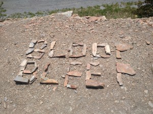
I had planned to go into Bland, VA to resupply, but I had overpacked so much I decided to skip right to Pearisburg. Around the interstate was a few miles of road walking with the cars zooming by. On top of one hill a hiker named Bloop Bleep had too much time:
I skipped the first water source since I got word it tasted terrible and I could see litter floating in it as I passed. Instead I filled up at Helveys Mill Shelter. The unfortunate part was that the shelter was 0.3 miles off trail and the water was 0.3 past that. It made for an extra 1.2 miles round trip! I stopped to eat at the shelter. Another hiker named Frosty was hanging out. We chatted for a few hours before I needed to head on. The next ridge without water was pretty long too (9.8). I got to the Jenny Knob Shelter and everyone was already in bed! I pitched my tent around 8:30.
Daily mileage: 23.8, AT mile: 599.5
I started off the next morning first thing and soon came to a climb. It was only 800′ but seemed to go on forever. I was glad to begin the descent.
Once I reached Kimberling creek and VA 606 I took a short detour over to Trent’s Grocery. There was promise of hot food and I wasn’t going to pass that up. The store wasn’t quite what I expected. It used to be a gas station and had an eclectic collection from fishing supplies, to food, to sodas, to beer (or was that counted in the fishing supplies?). The clientele was a show too. A man showed up to buy beer and walked off drinking it only to come back 30 mins later to buy more. Surely he had a problem since the Wild Boys, who had joined me at this point, told me that he tried to buy beer from all the campers at the bridge the night before.
Hiking on I decided to pass up Dismal Falls. I was trying for some decent mileage and I had already spent considerable time at Trent’s. Apparently the falls are a great place to camp and swim, regardless of the image you might get from the name.
There was about 7 miles of exceptionally flat trail and it wasn’t even punishing. I guess that was to make up for the gruesome climb back up to the ridge. It was 1200′ and very steep.
I came down to Sugar Run gap which leads to the wildly popular Woods Hole Hostel. Again I passed it up. I needed to get to Pearisburg the next day and I wanted to cover some more of those miles.
I finally made it to Docs Knob shelter. Not only was everyone asleep again (barely past dark), but it was packed. There were even people sleeping on the picnic tables! Since the previous few miles had very little camping and the guidebook showed none, I begrudgingly backtracked about 0.2 miles. On a trail of 2000 miles, walking backwards doesn’t help. Most hikers would press on a few miles in order to avoid even the slightest backtracking.
Daily mileage: 23.6, AT mile: 623.1
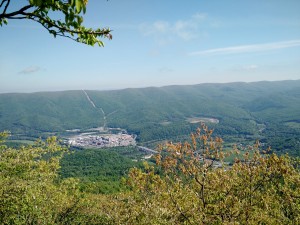
I found excellent camping locations as I went further in the morning. I guess I’ve just come to expect that these days. At the end of the ridge before town is a great lookout called Angels Rest. It had expansive views to the valley below.
Coming down that mountain was brutal. I can’t recall anything quite so steep and prolonged except maybe the climb down from Roan. That one was still probably easier. I saw a handful of day hikers headed up and I took pity on them.
I picked up my rental car as soon as I got to town. It was supposed to be a minivan, but I got stuck in some SUV. Today was the day I was headed to Trail Days, a huge Appalachian Trail festival in Damascus. I figured since I was going, I’d help get other hikers there. I ended up shuttling 15 people and made 3 trips. It took about 12 hours total and I didn’t get to my hotel until about 1:30 AM.
Daily mileage: 8.2, AT mile: 631.3, Driving Miles: ~630

